 MICHAEL
 · Gas Station Theory
Find the video before it is gone.
Offenders stop for fuel before and after. The cameras are already there, the footage ages out in days, and the canvass list gets built from memory at two in the morning. Gas Station Theory is Michele Kennedy's method, worked out at the Douglas County Sheriff's Office because she needed it. MICHAEL does the part a person should not have to: every station near the scene or the series, ranked, with hours, a sketch map, and the review window already on the sheet.
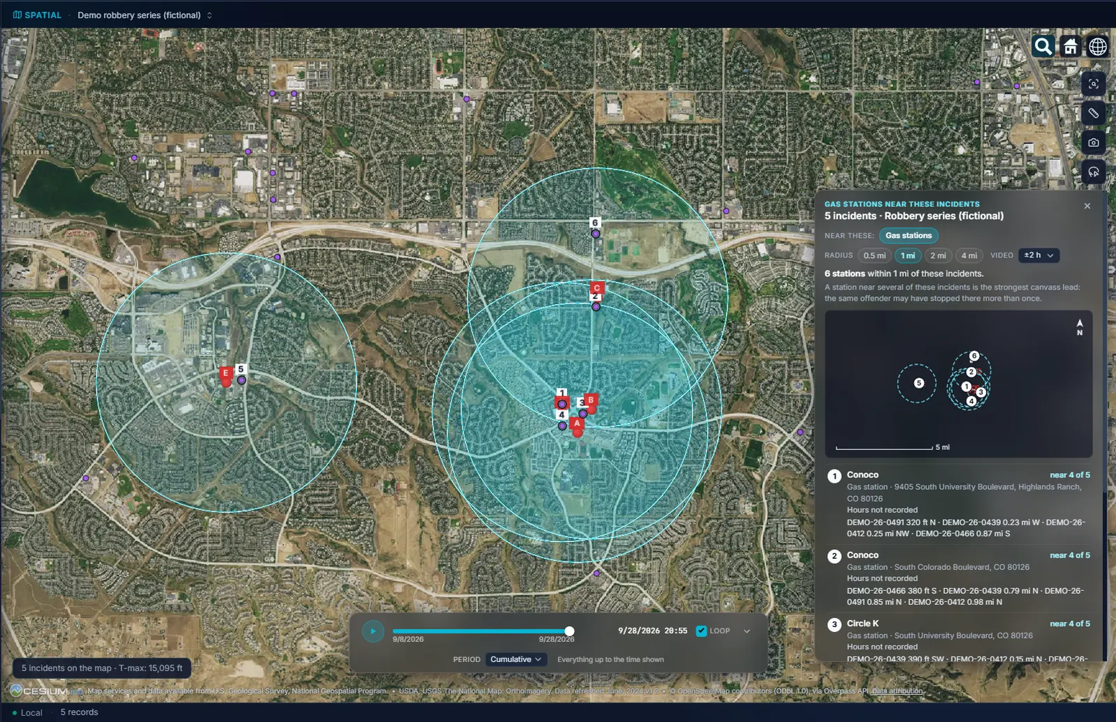
Gas Station Theory, worked out by an analyst who needed it.
The observation is Michele Kennedy's: offenders often stop at a gas station or convenience store before or after a violent crime, and the video there is rarely collected. The canvass is the follow-up, and it only works if it happens before the recorder overwrites.
- 01Every station within half a mile to four miles. Of a scene, or of a whole series. Ranked nearest first, with hours, distance and direction, a sketch map north up, and markers on the globe inside a ring that shows the radius you chose.
- 02A store and its pumps count as one stop. Fleet and private pumps the public cannot use are left out, and the list says how many.
- 03Open at the incident time. A station open 24 hours, or whose hours cover every incident, says so in the list. One that was closed is still listed, because its lot camera was not.
- 04The stations come from OpenStreetMap, or from you. Public map data loads around your incidents wherever the map is pointed. Your agency's own list of stations loads instead as a CSV, ranks the same way, and needs no internet connection at all.
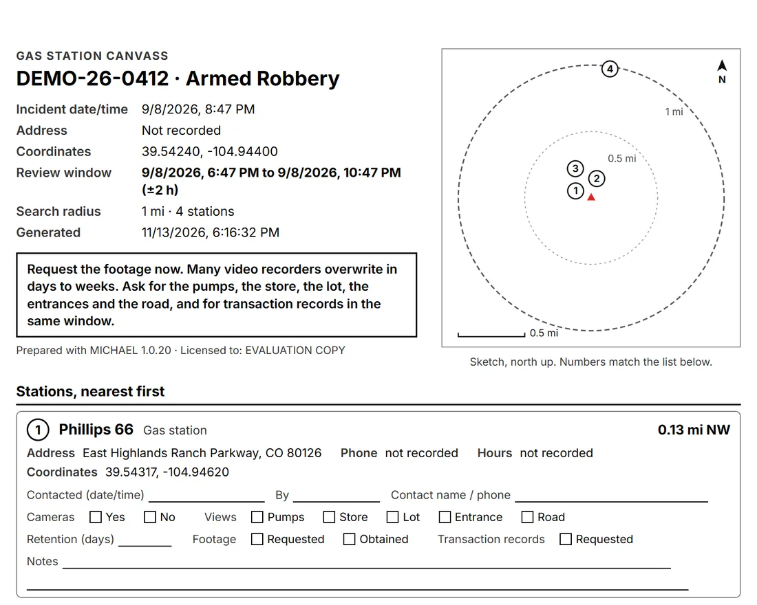
A canvass sheet with the review window already on it.
The detective walking into the station knows which hours of video to ask for before the clerk asks. One click prints it, Save PDF writes it to a file with the stamp and page number on every page, and a CSV comes with it when the list is long.
- 01The review window per incident. Each incident's time, plus and minus the margin you set (two hours by default), printed on the sheet as the window to request. Addresses are given to the block.
- 02A checklist per station. Contacted, by whom, the contact's name. Cameras yes or no. Which views: pumps, store, lot, entrances, road. Retention in days, footage requested or obtained, transaction records requested. Notes. The sheet is the record of the canvass, not just the list.
- 03The ask is printed at the top. Request the footage now; many recorders overwrite in days to weeks; ask for the pumps, the store, the lot, the entrances and the road, and for transaction records in the same window.
- 04It rides into the bulletin. The Crime Series Bulletin's patrol page carries the nearest stations beside the map, and the investigator version carries the full canvass list. Reports fetch nothing: the canvass lists what is already loaded, and offers to load it if nothing is.
Every incident card ends in a row of buttons.
One per place layer you have loaded. Gas stations is one of them; the rest are whatever your case needs, from transit stops to your own camera list.
- 01Near this, on one incident. One click lists everything in that layer within the distance you choose, nearest first, with distance and direction, and draws the radius as a ring over the imagery.
- 02Near these, on a series. Select several incidents, or open a series Series Finder found, and the list reranks by how many of them each place is near. The station close to one burglary is noise. The one close to six is a canvass.
- 03Twenty-three categories from public map data. Transit stations, bus stops, ATMs, banks, pawn shops, check cashing, liquor stores, bars, cannabis dispensaries, hotels, pharmacies, schools, parking, convenience stores, surveillance cameras and more, loaded as layers around your incidents. A category that is thinly mapped says so rather than looking empty, and a layer too far from your incidents says how far.
- 04Camera and LPR sites too. The same ranking runs over any loaded list of places, so a camera list is ordered by how many of the selected incidents fall within reach of each site, with its own camera canvass sheet.
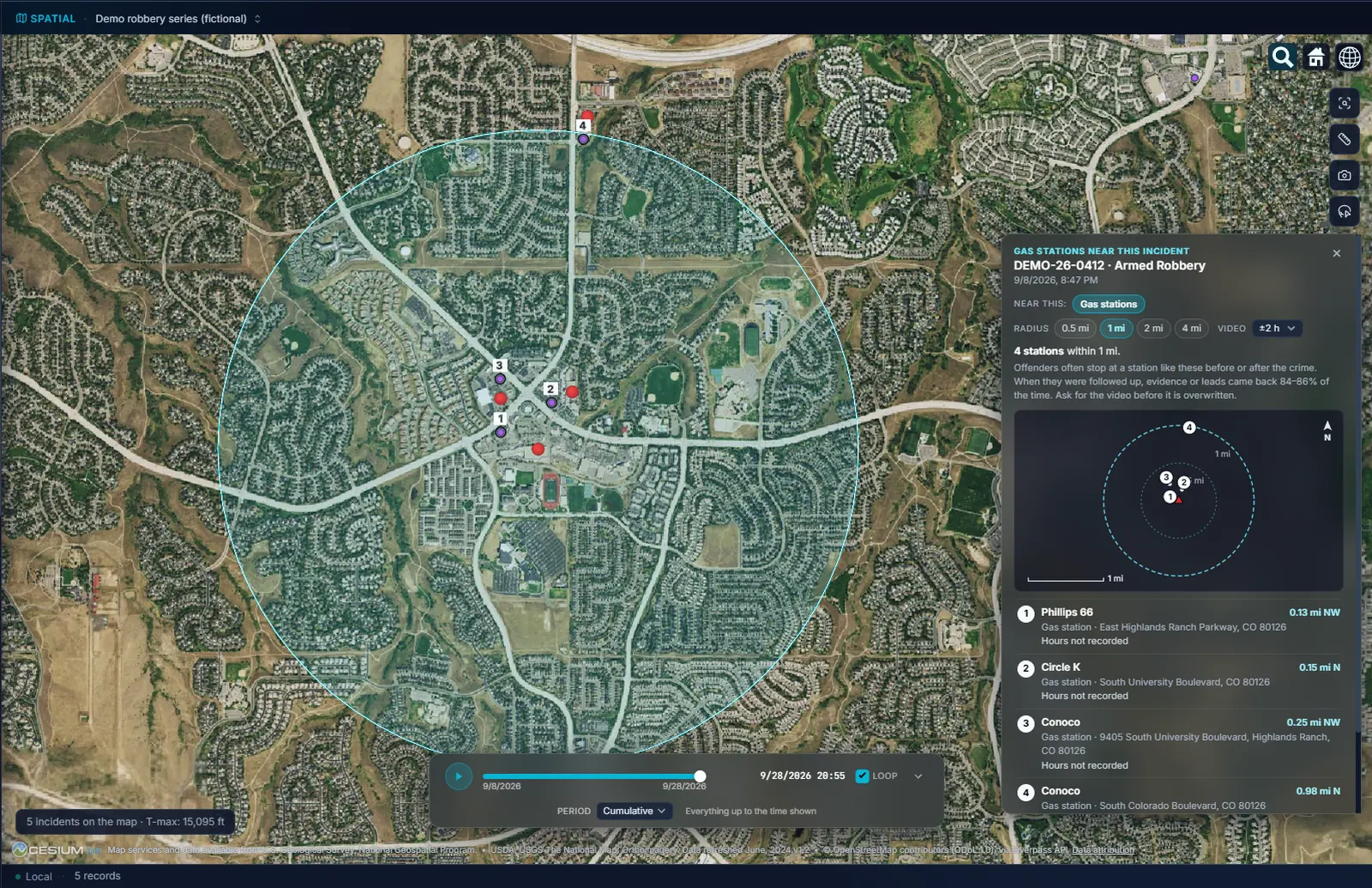
It lists the stations. The footage tells you who stopped.
A canvass list is a place to start, built fast enough to matter. The claims it makes are about distance and hours, and nothing else.
- 01Nearby is a lead, and the footage confirms it. A station near three of five incidents is the strongest lead on the list. It is still a lead, and the sheet is where the detective writes down what the footage actually showed.
- 02Public map data is only as complete as the public made it. A station missing from OpenStreetMap is missing from the list, which is why your own station list loads instead and why a thin category says it is thin.
- 03It asks only for what the list needs. Reports list what is already loaded. The map asks for places in a widened grid square, never around the exact point, and your incidents never leave the machine.
- 04The method is credited, every time. The sheet's footer carries Michele Kennedy's name and the Douglas County Sheriff's Office. The software did the arithmetic; the thinking was hers.
Try it on your own data.
Fourteen days, every feature, on one machine. Tell us who you are and we will email you your own download link. Nothing to activate. Your data stays on your machine and stays yours when the trial ends. No newsletter, no drip sequence.
Built for the people who do the work Sworn agencies, crime analysis units, public safety partners, and corporate investigation teams. Workstations are $2,500 a year, everything included. Academia and nonprofits: ask about license pricing.
Or email info@sworn.ai. A person answers.